


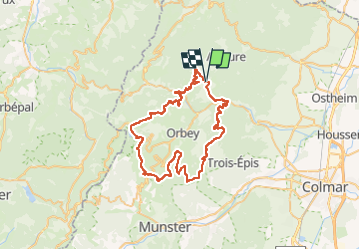
Fréland - Blancrupt

duchaine.nicolas
User

Length
56 km

Max alt
1123 m

Uphill gradient
1579 m
Km-Effort
78 km

Min alt
315 m

Downhill gradient
1585 m
Boucle
Yes
Creation date :
2022-10-30 09:11:39.567
Updated on :
2022-10-30 16:49:24.827
4h46
Difficulty : Medium
4h46
Difficulty : Medium

FREE GPS app for hiking
 SityTrail
IGN / Geographical institutes
SityTrail Plus
The world is yours!
About
Trail Mountain bike of 56 km to be discovered at Grand Est, Haut-Rhin, Fréland. This trail is proposed by duchaine.nicolas.
Description
Fréland - Labaroche - Col du Wettstein - Lac Noir - Lac Blanc Blancrupt - Surcenord - Les Mérelles - Col de Chamont
Positioning
Country:
France
Region :
Grand Est
Department/Province :
Haut-Rhin
Municipality :
Fréland
Location:
Unknown
Start:(Dec)
Start:(UTM)
365796 ; 5337170 (32U) N.
Comments