


22 10 29 Lachtelweier Fennematt

jmbilger
User
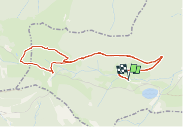

Length
6 km

Max alt
967 m

Uphill gradient
215 m
Km-Effort
8.9 km

Min alt
759 m

Downhill gradient
216 m
Boucle
Yes
Creation date :
2022-10-30 14:05:07.0
Updated on :
2022-10-30 16:08:30.782
1h41
Difficulty : Medium

FREE GPS app for hiking
 SityTrail
IGN / Geographical institutes
SityTrail Plus
The world is yours!
About
Trail Walking of 6 km to be discovered at Grand Est, Haut-Rhin, Kirchberg. This trail is proposed by jmbilger.
Positioning
Country:
France
Region :
Grand Est
Department/Province :
Haut-Rhin
Municipality :
Kirchberg
Location:
Unknown
Start:(Dec)
Start:(UTM)
344708 ; 5293801 (32T) N.
Comments