Trail Walking Collobrières - collobrieres, Lambert, laquina - Photo

collobrieres, Lambert, laquina

© OpenStreetMap contributors
Length
Length
16.9 km
Max alt
Max alt
600 m
Uphill gradient
Uphill gradient
702 m
Km-Effort
Km-Effort  
26 km
Min alt
Min alt
164 m
Downhill gradient
Downhill gradient
704 m
Boucle
Boucle
Yes
Creation date :
2022-11-02 08:18:38.82
Updated on :
2022-11-03 12:58:57.041

(0 Reviews)

Walking
Walking
6h31
Difficulty : Medium

Scan this QR Code to open this trail in the SityTrail application

FREE GPS app for hiking

Logo SityTrail SityTrail

IGN / Geographical institutes

Download SityTrail from the App Store Download SityTrail from Google Play

Logo SityTrail SityTrail World

The world is yours!

Download SityTrail from the App Store Download SityTrail from Google Play Download SityTrail on Huawei AppGallery

About

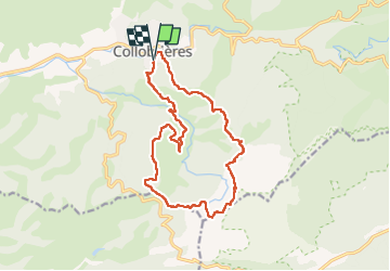
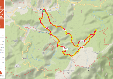
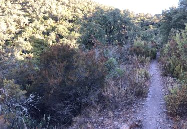
Trail Walking of 16.9 km to be discovered at Provence-Alpes-Côte d'Azur, Var, Collobrières. This trail is proposed by cdanielrando.

Description

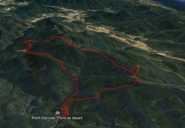
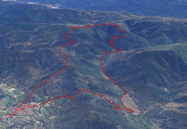
Du pk au cimetière, traverser le village pour rejoindre le Gr 90 qui vous conduit ,  en montée jusqu'au plateau  Lambert. Les deux menhirs bien visibles sont dans une prairie clôturée. Continuer sur le Gr et le quitter avant d'arriver au sommet du Laquina. Vue mer imprenable. Prendre à droite sur la dfci en direction du col du Babaou. Du sommet de Pertuade en direction de la Malière, bien suivre le tracé car le sentier non balisé est moins visible. Passé le gué de la haute Malière, le sentier en balcon monte avant de redescendre au pk

Elevation profile

Photos

Positioning

Country:
France
Region :
Provence-Alpes-Côte d'Azur
Department/Province :
Var
Municipality :
Collobrières
Location:
Unknown
Start:(UTM)
281542 ; 4790461 (32T) N.

Trails nearby

Trail Walking Collobrières - 10881733-Collobrières - La Verne - radar - Photo
Walking
GUIDE
affinetataille

Walking

Medium
(1)
Collobrières, Provence-Alpes-Côte d'Azur, Var, France
14.4 km | 21 km-effort
6h 0min
Yes
Trail Walking Collobrières - SityTrail - Collobriéres - Menhirs de Lambert - Photo
Walking
GUIDE
affinetataille

Walking

Medium
(1)
Collobrières, Provence-Alpes-Côte d'Azur, Var, France
12.8 km | 20 km-effort
6h 0min
Yes
Trail Mountain bike Collobrières - Collobrières par pistes - Photo
Mountain bike
GrouGary

Mountain bike

Medium
(1)
Collobrières, Provence-Alpes-Côte d'Azur, Var, France
28 km | 35 km-effort
2h 20min
Yes
Trail Walking Collobrières - Plateau Lambert 2 - Photo
Walking
frizou83

Walking

Easy
(1)
Collobrières, Provence-Alpes-Côte d'Azur, Var, France
14.2 km | 21 km-effort
4h 40min
Yes
Trail Walking Collobrières - plateau Lambert en partant de Collobrieres - Photo
Walking
FSantoni

Walking

Very difficult
Collobrières, Provence-Alpes-Côte d'Azur, Var, France
15.2 km | 22 km-effort
6h 58min
Yes
Trail Walking Collobrières - Les Maures-Collobrières-15-03-23 - Photo
Walking
Christiancordin

Walking

Medium
Collobrières, Provence-Alpes-Côte d'Azur, Var, France
18.1 km | 26 km-effort
4h 47min
Yes
Trail Walking Collobrières - SityTrail - chapelle st guillaume  - Photo
Walking
GUIDE
affinetataille

Walking

Difficult
Collobrières, Provence-Alpes-Côte d'Azur, Var, France
14.1 km | 22 km-effort
6h 0min
Yes
Trail Walking Collobrières - La Verne - Cèdres de Ragusse by DAL - Photo
Walking
dany83ynad

Walking

Very difficult
Collobrières, Provence-Alpes-Côte d'Azur, Var, France
14.5 km | 19.9 km-effort
5h 34min
Yes
Trail Mountain bike Collobrières - Cretofeu - Photo
Mountain bike
Damien Restano

Mountain bike

Medium
Collobrières, Provence-Alpes-Côte d'Azur, Var, France
39 km | 53 km-effort
3h 48min
No


Close
My subscriptions