Trail Mountain bike Aachen - Eu.Kopfchen51km572m+VTC - Photo
© OpenStreetMap contributors
Length
Length
51 km
Max alt
Max alt
357 m
Uphill gradient
Uphill gradient
691 m
Km-Effort
Km-Effort  
60 km
Min alt
Min alt
125 m
Downhill gradient
Downhill gradient
683 m
Boucle
Boucle
Yes
Creation date :
2014-12-10 00:00:00.0
Updated on :
2014-12-10 00:00:00.0

(0 Reviews)

Mountain bike
Mountain bike
3h54
Difficulty : Easy

Scan this QR Code to open this trail in the SityTrail application

FREE GPS app for hiking

Logo SityTrail SityTrail

IGN / Geographical institutes

Download SityTrail from the App Store Download SityTrail from Google Play

Logo SityTrail SityTrail World

The world is yours!

Download SityTrail from the App Store Download SityTrail from Google Play Download SityTrail on Huawei AppGallery

About

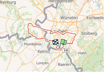
Trail Mountain bike of 51 km to be discovered at North Rhine-Westphalia, Städteregion Aachen, Aachen. This trail is proposed by francois58.

Description

Boucle tous chemins sur l'Allemagne et les Pays-Bas. Forêts, Ravel, traversée d'Aachen (Dom et Rathaus), remontée sur les 3 frontières.Possibilité de raccourir à 31 km

Elevation profile

Positioning

Country:
Germany
Region :
North Rhine-Westphalia
Department/Province :
Städteregion Aachen
Municipality :
Aachen
Location:
Aachen-Mitte
Start:(UTM)
294610 ; 5623204 (32U) N.

Trails nearby

Trail Walking Raeren - 2023-09-21_15h54m11_392.gpx.xml - Photo
Walking
GUIDE
mumu.larandonneuse

Walking

Medium
(1)
Raeren, Wallonia, Liège, Belgium
13.2 km | 17.3 km-effort
3h 55min
Yes
Trail Walking Aachen - Aix-la-Chapelle  - Photo
Walking
GUIDE
mumu.larandonneuse

Walking

Easy
(1)
Aachen, North Rhine-Westphalia, Städteregion Aachen, Germany
11.4 km | 15.4 km-effort
3h 30min
Yes
Trail Walking Aachen - Aix-la-Chapelle  - Photo
Walking
GUIDE
mumu.larandonneuse

Walking

Easy
(1)
Aachen, North Rhine-Westphalia, Städteregion Aachen, Germany
11.1 km | 13.4 km-effort
3h 2min
Yes
Trail Walking Raeren - 2022-01-18_14h11m36_lichtenbusch - Photo
Walking
GUIDE
mumu.larandonneuse

Walking

Easy
(2)
Raeren, Wallonia, Liège, Belgium
14.8 km | 17 km-effort
3h 52min
Yes
Trail Walking Raeren - 2021-04-02_18h39m41_975 - Photo
Walking
GUIDE
mumu.larandonneuse

Walking

Easy
(1)
Raeren, Wallonia, Liège, Belgium
14.6 km | 17.8 km-effort
4h 2min
Yes
Trail Walking Kelmis - 20200730 - Les 3 Bornes 7.3 Km - Photo
Walking
GUIDE
pierreh01

Walking

Difficult
(1)
Kelmis, Wallonia, Liège, Belgium
7.4 km | 10.4 km-effort
1h 50min
Yes
Trail Walking Raeren - Venn trilogie (2eme étape) - Photo
Walking
Godasses et Grosses Pattes

Walking

Easy
(1)
Raeren, Wallonia, Liège, Belgium
21 km | 25 km-effort
4h 15min
No
Trail Walking Kelmis - Venn Trilogie (1er étape) - Photo
Walking
Godasses et Grosses Pattes

Walking

Medium
(1)
Kelmis, Wallonia, Liège, Belgium
25 km | 30 km-effort
5h 0min
No
Trail Walking Raeren - RB-Lg-30_Hauset_via-racc-2 - Photo
Walking
PRO

Walking

(3)
Raeren, Wallonia, Liège, Belgium
13.3 km | 15.9 km-effort
3h 37min
Yes


Close
My subscriptions