


Forêt domaniale de la Gardiole

Lobin
User
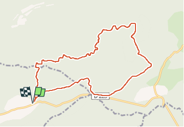

Length
10.9 km

Max alt
564 m

Uphill gradient
175 m
Km-Effort
13.2 km

Min alt
448 m

Downhill gradient
176 m
Boucle
Yes
Creation date :
2022-11-04 09:00:11.0
Updated on :
2022-11-05 21:48:29.447
2h05
Difficulty : Medium

FREE GPS app for hiking
 SityTrail
IGN / Geographical institutes
SityTrail Plus
The world is yours!
About
Trail Walking of 10.9 km to be discovered at Provence-Alpes-Côte d'Azur, Bouches-du-Rhône, Vauvenargues. This trail is proposed by Lobin.
Positioning
Country:
France
Region :
Provence-Alpes-Côte d'Azur
Department/Province :
Bouches-du-Rhône
Municipality :
Vauvenargues
Location:
Unknown
Start:(Dec)
Start:(UTM)
717048 ; 4825858 (31T) N.
Comments