


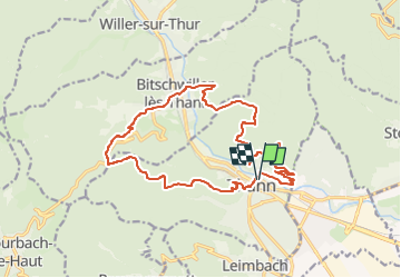
Autour de Thann

Alain28/01
User

Length
17.9 km

Max alt
633 m

Uphill gradient
730 m
Km-Effort
28 km

Min alt
327 m

Downhill gradient
728 m
Boucle
Yes
Creation date :
2022-11-06 09:35:55.941
Updated on :
2022-11-06 09:36:47.074
6h17
Difficulty : Very difficult

FREE GPS app for hiking
 SityTrail
IGN / Geographical institutes
SityTrail Plus
The world is yours!
About
Trail Walking of 17.9 km to be discovered at Grand Est, Haut-Rhin, Thann. This trail is proposed by Alain28/01.
Positioning
Country:
France
Region :
Grand Est
Department/Province :
Haut-Rhin
Municipality :
Thann
Location:
Unknown
Start:(Dec)
Start:(UTM)
358079 ; 5297052 (32T) N.
Comments