Trail On foot Chédigny - Amboise - J2 G1 - Chédigny et visite du village - Photo

Amboise - J2 G1 - Chédigny et visite du village

Club randonnées SERVON

© OpenStreetMap contributors
Length
Length
15.9 km
Max alt
Max alt
104 m
Uphill gradient
Uphill gradient
174 m
Km-Effort
Km-Effort  
18.2 km
Min alt
Min alt
61 m
Downhill gradient
Downhill gradient
174 m
Boucle
Boucle
Yes
Creation date :
2022-11-07 11:05:28.252
Updated on :
2023-05-10 15:39:13.028

(0 Reviews)

On foot
On foot
4h08
Difficulty : Easy

Scan this QR Code to open this trail in the SityTrail application

FREE GPS app for hiking

Logo SityTrail SityTrail

IGN / Geographical institutes

Download SityTrail from the App Store Download SityTrail from Google Play

Logo SityTrail SityTrail World

The world is yours!

Download SityTrail from the App Store Download SityTrail from Google Play Download SityTrail on Huawei AppGallery

About

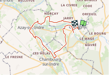
Trail On foot of 15.9 km to be discovered at Centre-Loire Valley, Indre-et-Loire, Chédigny. This trail is proposed by Les 1000 pattes.

Description

Parking cimetière communal de Chédigny sur D10
Pouvant être raccourcie au lieu-dit le Grand Chêne direction Morillon

Elevation profile

Points of interest

Point of interest Chédigny - Chédigny - Photo
cramcl50
CHÉDIGNY 
Point of interest Chédigny - le hameau de la Rochette - Photo
cramcl50
Point of interest Azay-sur-Indre - le château de la Follaine - Photo
cramcl50
Point of interest Azay-sur-Indre - le moulin de la Follaine - Photo
cramcl50
AZAY-SUR-INDRE 
Point of interest Azay-sur-Indre - l'Indrois - Photo
cramcl50
AZAY-SUR-INDRE 
Point of interest Azay-sur-Indre - Pique nique - Photo
cramcl50
AZAY-SUR-INDRE 
Point of interest Chédigny - l'éolienne  Bollée - Photo
cramcl50

Positioning

Country:
France
Region :
Centre-Loire Valley
Department/Province :
Indre-et-Loire
Municipality :
Chédigny
Location:
Unknown
Start:(UTM)
348604 ; 5230123 (31T) N.

Trails nearby

Trail Walking Chédigny - Chedigny 9km - Photo
Walking
MichelRando7656

Walking

Medium
Chédigny, Centre-Loire Valley, Indre-et-Loire, France
10.9 km | 12.3 km-effort
3h 13min
Yes
Trail On foot Chédigny - Circuit Chédigny - Photo
On foot
PRO

On foot

Easy
Chédigny, Centre-Loire Valley, Indre-et-Loire, France
12.8 km | 14.7 km-effort
3h 20min
Yes
Trail On foot Chambourg-sur-Indre - Entre Indre et Indrois - Photo
On foot
PRO

On foot

Easy
Chambourg-sur-Indre, Centre-Loire Valley, Indre-et-Loire, France
10.4 km | 12.1 km-effort
2h 45min
Yes
Trail Walking Chambourg-sur-Indre - Chambourg-sur-Indre - l'Isle Auger Loches GR46 - 26.7km 325m 5h40 (30mn) - 2021 07 24 - Photo
Walking
Orcal37

Walking

Easy
Chambourg-sur-Indre, Centre-Loire Valley, Indre-et-Loire, France
27 km | 31 km-effort
5h 40min
Yes
Trail Walking Azay-sur-Indre - Azay-sur-Indre - GR46 PR Chambourg-sur-Indre - 18.2km 200m 2h55 (23mn) - 2021 03 06 - Photo
Walking
Orcal37

Walking

Easy
Azay-sur-Indre, Centre-Loire Valley, Indre-et-Loire, France
18.2 km | 21 km-effort
3h 55min
Yes
Trail Walking Chédigny - Chédigny - Photo
Walking
fustier

Walking

Very difficult
(1)
Chédigny, Centre-Loire Valley, Indre-et-Loire, France
19.5 km | 22 km-effort
4h 53min
Yes
Trail Walking Chambourg-sur-Indre - Chambourg-sur-Indre - Photo
Walking
LEMENIO

Walking

Medium
Chambourg-sur-Indre, Centre-Loire Valley, Indre-et-Loire, France
13.4 km | 15.3 km-effort
3h 20min
No
Trail Walking Chédigny - 10K-Chedigny - Photo
Walking
Robert62

Walking

Very easy
Chédigny, Centre-Loire Valley, Indre-et-Loire, France
10.4 km | 11.8 km-effort
3h 20min
Yes
Trail Hybrid bike Saint-Quentin-sur-Indrois - vallée de l'Indrois Montresor chedigny - Photo
Hybrid bike
jeanjean37

Hybrid bike

Medium
Saint-Quentin-sur-Indrois, Centre-Loire Valley, Indre-et-Loire, France
55 km | 64 km-effort
3h 36min
Yes


Close
My subscriptions