


Trace Lourdios Guy

mitch1952
User
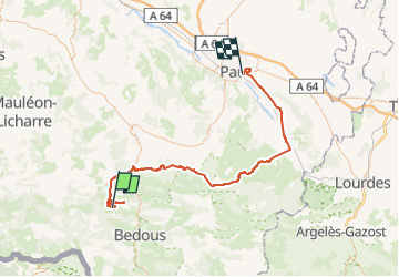

Length
90 km

Max alt
984 m

Uphill gradient
1833 m
Km-Effort
115 km

Min alt
193 m

Downhill gradient
2090 m
Boucle
No
Creation date :
2022-11-10 08:17:38.0
Updated on :
2022-11-10 15:56:53.332
7h36
Difficulty : Very difficult

FREE GPS app for hiking
 SityTrail
IGN / Geographical institutes
SityTrail Plus
The world is yours!
About
Trail Walking of 90 km to be discovered at New Aquitaine, Pyrénées-Atlantiques, Lourdios-Ichère. This trail is proposed by mitch1952.
Positioning
Country:
France
Region :
New Aquitaine
Department/Province :
Pyrénées-Atlantiques
Municipality :
Lourdios-Ichère
Location:
Unknown
Start:(Dec)
Start:(UTM)
690128 ; 4768901 (30T) N.
Comments