


Charmant à cheval à pied 14-09-2014

jmrobin
User
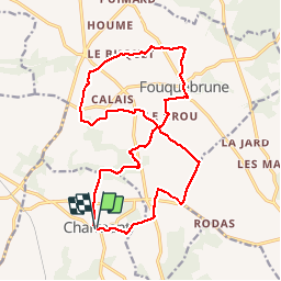

Length
19.3 km

Max alt
167 m

Uphill gradient
215 m
Km-Effort
22 km

Min alt
102 m

Downhill gradient
218 m
Boucle
Yes
Creation date :
2019-03-04 10:38:12.54
Updated on :
2019-03-04 10:38:12.585
4h50
Difficulty : Easy

FREE GPS app for hiking
 SityTrail
IGN / Geographical institutes
SityTrail Plus
The world is yours!
About
Trail Walking of 19.3 km to be discovered at New Aquitaine, Charente, Boisné-la-Tude. This trail is proposed by jmrobin.
Description
Circuit proposé dans le cadre de Charmant à Cheval. Attention, certains chemins sont privés donc peuvent être inaccessibles en temps normal.
Positioning
Country:
France
Region :
New Aquitaine
Department/Province :
Charente
Municipality :
Boisné-la-Tude
Location:
Unknown
Start:(Dec)
Start:(UTM)
279941 ; 5041949 (31T) N.
Comments