


steinwaseñ

jcschubnel
User
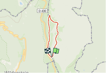

Length
4.4 km

Max alt
1302 m

Uphill gradient
194 m
Km-Effort
7 km

Min alt
1113 m

Downhill gradient
198 m
Boucle
Yes
Creation date :
2022-10-27 10:23:01.941
Updated on :
2022-11-13 21:10:24.552
2h39
Difficulty : Medium

FREE GPS app for hiking
 SityTrail
IGN / Geographical institutes
SityTrail Plus
The world is yours!
About
Trail Walking of 4.4 km to be discovered at Grand Est, Haut-Rhin, Metzeral. This trail is proposed by jcschubnel.
Positioning
Country:
France
Region :
Grand Est
Department/Province :
Haut-Rhin
Municipality :
Metzeral
Location:
Unknown
Start:(Dec)
Start:(UTM)
349443 ; 5316515 (32T) N.
Comments