


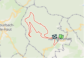
Parking mairie de Rammersmatt - Spannplatz -Kuschelbach - triangle jaune - Abri du Hochburg et retour

patrickbeyrath
User

Length
8.4 km

Max alt
717 m

Uphill gradient
302 m
Km-Effort
12.4 km

Min alt
492 m

Downhill gradient
304 m
Boucle
Yes
Creation date :
2022-11-24 07:14:41.679
Updated on :
2022-11-25 07:14:05.296
2h43
Difficulty : Medium

FREE GPS app for hiking
 SityTrail
IGN / Geographical institutes
SityTrail Plus
The world is yours!
About
Trail Walking of 8.4 km to be discovered at Grand Est, Haut-Rhin, Rammersmatt. This trail is proposed by patrickbeyrath.
Positioning
Country:
France
Region :
Grand Est
Department/Province :
Haut-Rhin
Municipality :
Rammersmatt
Location:
Unknown
Start:(Dec)
Start:(UTM)
355318 ; 5294653 (32T) N.
Comments