


soultzmat. osenburg

Alain28/01
User
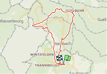

Length
18.1 km

Max alt
768 m

Uphill gradient
580 m
Km-Effort
26 km

Min alt
293 m

Downhill gradient
586 m
Boucle
Yes
Creation date :
2022-11-24 09:36:33.306
Updated on :
2022-11-26 18:17:39.835
3h39
Difficulty : Medium

FREE GPS app for hiking
 SityTrail
IGN / Geographical institutes
SityTrail Plus
The world is yours!
About
Trail Walking of 18.1 km to be discovered at Grand Est, Haut-Rhin, Soultzmatt. This trail is proposed by Alain28/01.
Positioning
Country:
France
Region :
Grand Est
Department/Province :
Haut-Rhin
Municipality :
Soultzmatt
Location:
Unknown
Start:(Dec)
Start:(UTM)
367215 ; 5314370 (32T) N.
Comments