


Soultzmatt - Osenbuhr

Alain28/01
User
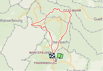

Length
15.5 km

Max alt
769 m

Uphill gradient
518 m
Km-Effort
22 km

Min alt
310 m

Downhill gradient
515 m
Boucle
Yes
Creation date :
2022-11-26 18:33:31.229
Updated on :
2022-11-26 18:35:30.981
5h05
Difficulty : Medium

FREE GPS app for hiking
 SityTrail
IGN / Geographical institutes
SityTrail Plus
The world is yours!
About
Trail On foot of 15.5 km to be discovered at Grand Est, Haut-Rhin, Soultzmatt. This trail is proposed by Alain28/01.
Positioning
Country:
France
Region :
Grand Est
Department/Province :
Haut-Rhin
Municipality :
Soultzmatt
Location:
Unknown
Start:(Dec)
Start:(UTM)
366783 ; 5314387 (32T) N.
Comments