Trail Walking Entrages - 04 Le Cousson, circuit original par Les Courtiers  - Photo

04 Le Cousson, circuit original par Les Courtiers

© OpenStreetMap contributors
Length
Length
12 km
Max alt
Max alt
1472 m
Uphill gradient
Uphill gradient
839 m
Km-Effort
Km-Effort  
23 km
Min alt
Min alt
763 m
Downhill gradient
Downhill gradient
836 m
Boucle
Boucle
Yes
Creation date :
2022-12-01 08:27:51.607
Updated on :
2022-12-01 15:19:30.134

(0 Reviews)

Walking
Walking
5h30
Difficulty : Difficult

Scan this QR Code to open this trail in the SityTrail application

FREE GPS app for hiking

Logo SityTrail SityTrail

IGN / Geographical institutes

Download SityTrail from the App Store Download SityTrail from Google Play

Logo SityTrail SityTrail World

The world is yours!

Download SityTrail from the App Store Download SityTrail from Google Play Download SityTrail on Huawei AppGallery

About

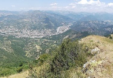
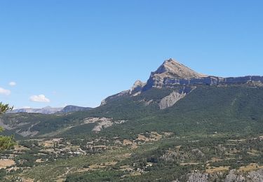
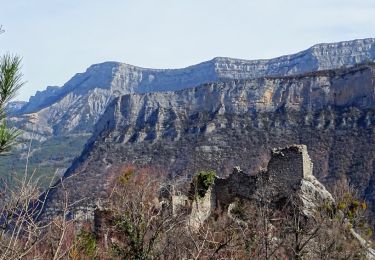
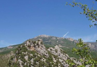
Trail Walking of 12 km to be discovered at Provence-Alpes-Côte d'Azur, Alpes-de-Haute-Provence, Entrages. This trail is proposed by Cosmos .

Description

Hors sentier entre Le Merle et Le Pas d'Entrages ("bartassage" sérieux sur 200m)

Elevation profile

Positioning

Country:
France
Region :
Provence-Alpes-Côte d'Azur
Department/Province :
Alpes-de-Haute-Provence
Municipality :
Entrages
Location:
Unknown
Start:(UTM)
279258 ; 4878464 (32T) N.

Trails nearby

Trail Walking Entrages - CHABRIERES Pas de l Ane Entrages Pas des Portes clubs navette  - Photo
Walking
RobinMicheline

Walking

Medium
(1)
Entrages, Provence-Alpes-Côte d'Azur, Alpes-de-Haute-Provence, France
15.5 km | 26 km-effort
6h 49min
No
Trail Walking Chaudon-Norante - ENTRAGES la Clappe départ ancienne carrière Gozzi - Photo
Walking
RobinMicheline

Walking

Medium
(1)
Chaudon-Norante, Provence-Alpes-Côte d'Azur, Alpes-de-Haute-Provence, France
12.8 km | 19.9 km-effort
4h 7min
Yes
Trail On foot Entrages - Le Sommet du Cousson - Photo
On foot
PRO

On foot

Medium
Entrages, Provence-Alpes-Côte d'Azur, Alpes-de-Haute-Provence, France
11.8 km | 21 km-effort
4h 50min
Yes
Trail Walking Digne-les-Bains - ENTRAGES Tour et crête du Feston o s l - Photo
Walking
RobinMicheline

Walking

Medium
Digne-les-Bains, Provence-Alpes-Côte d'Azur, Alpes-de-Haute-Provence, France
12.7 km | 18.7 km-effort
4h 13min
Yes
Trail Walking Chaudon-Norante - Ruines hameau Creisset par Passerelle Asse - Photo
Walking
GrouGary

Walking

Easy
Chaudon-Norante, Provence-Alpes-Côte d'Azur, Alpes-de-Haute-Provence, France
8.8 km | 15.2 km-effort
4h 14min
No
Trail Walking Chaudon-Norante - Hameau de Creisset - Photo
Walking
Nicomontagnes

Walking

Very easy
(1)
Chaudon-Norante, Provence-Alpes-Côte d'Azur, Alpes-de-Haute-Provence, France
9.5 km | 15.6 km-effort
3h 39min
Yes
Trail Walking Beynes - Boucle de Palus - Beynes - Photo
Walking
tracegps

Walking

Medium
Beynes, Provence-Alpes-Côte d'Azur, Alpes-de-Haute-Provence, France
7.8 km | 11 km-effort
2h 0min
Yes
Trail Mountain bike Chaudon-Norante - Grande Traversée des PréAlpes à VTT : Col de Pierre Basse - La Bâtie Neuve (Maison forestière ruinée) - Photo
Mountain bike
tracegps

Mountain bike

Medium
Chaudon-Norante, Provence-Alpes-Côte d'Azur, Alpes-de-Haute-Provence, France
15.1 km | 20 km-effort
3h 0min
No
Trail Mountain bike Digne-les-Bains - Grande Traversée des PréAlpes à VTT : La Jasse - Col de Pierre Basse - Photo
Mountain bike
tracegps

Mountain bike

Difficult
Digne-les-Bains, Provence-Alpes-Côte d'Azur, Alpes-de-Haute-Provence, France
24 km | 35 km-effort
3h 30min
No


Close
My subscriptions