


Course Arles-Corsavy

patbt
User
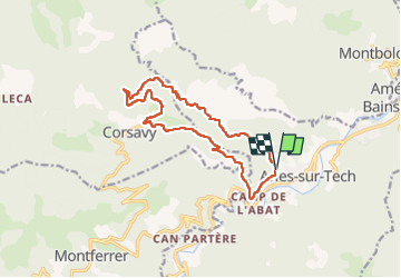

Length
14.4 km

Max alt
762 m

Uphill gradient
470 m
Km-Effort
21 km

Min alt
311 m

Downhill gradient
473 m
Boucle
Yes
Creation date :
2022-12-04 09:11:23.571
Updated on :
2022-12-04 11:24:34.683
2h11
Difficulty : Medium

FREE GPS app for hiking
 SityTrail
IGN / Geographical institutes
SityTrail Plus
The world is yours!
About
Trail Running of 14.4 km to be discovered at Occitania, Pyrénées-Orientales, Arles-sur-Tech. This trail is proposed by patbt.
Positioning
Country:
France
Region :
Occitania
Department/Province :
Pyrénées-Orientales
Municipality :
Arles-sur-Tech
Location:
Unknown
Start:(Dec)
Start:(UTM)
469140 ; 4700651 (31T) N.
Comments