![](/images/other/stat-length.png)
![Trail Walking Durfort-Lacapelette - SityTrail - CC_Velay_EA_17_Lauzerte_Moissac_20080817 - Photo](https://media.geolcdn.com/t/1900/400/ext.pjpeg?maxdim=2&url=https%3A%2F%2Fstatic1.geolcdn.com%2Fsiteimages%2Fupload%2Ffiles%2F1553511878bg_sport_marche.png)
SityTrail - CC_Velay_EA_17_Lauzerte_Moissac_20080817
Christianlabourie
User
![Length](/images/other/stat-length.png)
Length
14.8 km
![Max alt](https://static1.geolcdn.com/siteimages/upload/files/1508320355ic_sort_altitude_max_24dp.png)
Max alt
195 m
![Uphill gradient](https://static1.geolcdn.com/siteimages/upload/files/1508320355ic_sort_den_pos_24dp.png)
Uphill gradient
224 m
![Km-Effort](/images/other/stat-length.png)
Km-Effort
18.1 km
![Min alt](https://static1.geolcdn.com/siteimages/upload/files/1508320355ic_sort_altitude_min_24dp.png)
Min alt
72 m
![Downhill gradient](https://static1.geolcdn.com/siteimages/upload/files/1508320355ic_sort_den_neg_24dp.png)
Downhill gradient
343 m
![Boucle](https://static1.geolcdn.com/siteimages/upload/files/16400158638029165_repeat_loop_refresh_sync_direction_icon.png)
Boucle
No
Creation date :
2022-12-06 14:35:09.443
Updated on :
2023-02-14 22:30:55.294
![Walking](https://static1.geolcdn.com/sitytour/trail-icons/101.png)
7h35
Difficulty : Very difficult
![Scan this QR Code to open this trail in the SityTrail application](https://capi.geolives.com/qq0zvz2zws4bq2lad0pu/sitytour/trails/3475340/qr.png?size=200)
FREE GPS app for hiking
About
Trail Walking of 14.8 km to be discovered at Occitania, Tarn-et-Garonne, Durfort-Lacapelette. This trail is proposed by Christianlabourie.
Description
Randonnée Marche de 26 km à découvrir à Occitanie, Tarn-et-Garonne, Lauzerte. Cette randonnée est proposée par patrickdanilo.
Positioning
Country:
France
Region :
Occitania
Department/Province :
Tarn-et-Garonne
Municipality :
Durfort-Lacapelette
Location:
Unknown
Start:(Dec)
Start:(UTM)
352512 ; 4894173 (31T) N.
Comments
Trails nearby
![Trail Walking Durfort-Lacapelette - Mon Compostelle neuvième étape - Photo](https://media.geolcdn.com/t/375/260/ext.jpg?maxdim=2&url=https%3A%2F%2Fservices.sitytrail.com%2FGeolivesWS%2FDownloadMedia.ashx%3FTrailID%3D684076%26Media%3Dcf9f196a-5b71-43f7-b867-ea4ea4fb3350.JPG)
![Walking Walking](https://static1.geolcdn.com/sitytour/trail-icons/101.png)
Mon Compostelle neuvième étape
Walking
Difficult
Durfort-Lacapelette,
Occitania,
Tarn-et-Garonne,
France
![](/images/other/stat-length.png)
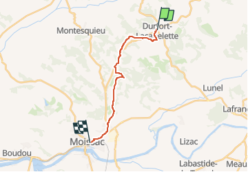
49 km | 58 km-effort
10h 20min
![](https://static1.geolcdn.com/siteimages/upload/files/16400158638029165_repeat_loop_refresh_sync_direction_icon.png)
No
![Trail Walking Durfort-Lacapelette - St Martin - Bouillan - Chemin de Compostelle - Photo](https://media.geolcdn.com/t/375/260/ext.jpg?maxdim=2&url=https%3A%2F%2Fservices.sitytrail.com%2FGeolivesWS%2FDownloadMedia.ashx%3FTrailID%3D109582%26Media%3D4205_5.jpg)
![Walking Walking](https://static1.geolcdn.com/sitytour/trail-icons/101.png)
St Martin - Bouillan - Chemin de Compostelle
Walking
Very difficult
Durfort-Lacapelette,
Occitania,
Tarn-et-Garonne,
France
![](/images/other/stat-length.png)
26 km | 30 km-effort
10h 0min
![](https://static1.geolcdn.com/siteimages/upload/files/16400158638029165_repeat_loop_refresh_sync_direction_icon.png)
No
![Trail Walking Durfort-Lacapelette - Etape Durfort-Lacapelette à Moissac - Photo](https://media.geolcdn.com/t/375/260/ext.jpg?maxdim=2&url=https%3A%2F%2Fstatic1.geolcdn.com%2Fsiteimages%2Fupload%2Ffiles%2F1553511878bg_sport_marche.png)
![Walking Walking](https://static1.geolcdn.com/sitytour/trail-icons/101.png)
Etape Durfort-Lacapelette à Moissac
Walking
Easy
Durfort-Lacapelette,
Occitania,
Tarn-et-Garonne,
France
![](/images/other/stat-length.png)
16.2 km | 21 km-effort
4h 22min
![](https://static1.geolcdn.com/siteimages/upload/files/16400158638029165_repeat_loop_refresh_sync_direction_icon.png)
No
![Trail Walking Durfort-Lacapelette - Compostelle 19 - Durfort-Lacapelette -> Moissac - Photo](https://media.geolcdn.com/t/375/260/ext.jpg?maxdim=2&url=https%3A%2F%2Fstatic1.geolcdn.com%2Fsiteimages%2Fupload%2Ffiles%2F1553511878bg_sport_marche.png)
![Walking Walking](https://static1.geolcdn.com/sitytour/trail-icons/101.png)
Compostelle 19 - Durfort-Lacapelette -> Moissac
Walking
Very easy
Durfort-Lacapelette,
Occitania,
Tarn-et-Garonne,
France
![](/images/other/stat-length.png)
17.8 km | 22 km-effort
4h 38min
![](https://static1.geolcdn.com/siteimages/upload/files/16400158638029165_repeat_loop_refresh_sync_direction_icon.png)
No
![Trail Walking Durfort-Lacapelette - St Jacques Étape 21 - Photo](https://media.geolcdn.com/t/375/260/ext.jpg?maxdim=2&url=https%3A%2F%2Fstatic1.geolcdn.com%2Fsiteimages%2Fupload%2Ffiles%2F1553511878bg_sport_marche.png)
![Walking Walking](https://static1.geolcdn.com/sitytour/trail-icons/101.png)
St Jacques Étape 21
Walking
Very easy
Durfort-Lacapelette,
Occitania,
Tarn-et-Garonne,
France
![](/images/other/stat-length.png)
15.6 km | 18.5 km-effort
4h 7min
![](https://static1.geolcdn.com/siteimages/upload/files/16400158638029165_repeat_loop_refresh_sync_direction_icon.png)
No
![Trail Walking Durfort-Lacapelette - enregistrement Lauzerte-Chapelle d'espis - Photo](https://media.geolcdn.com/t/375/260/ext.jpg?maxdim=2&url=https%3A%2F%2Fstatic1.geolcdn.com%2Fsiteimages%2Fupload%2Ffiles%2F1553511878bg_sport_marche.png)
![Walking Walking](https://static1.geolcdn.com/sitytour/trail-icons/101.png)
enregistrement Lauzerte-Chapelle d'espis
Walking
Very difficult
Durfort-Lacapelette,
Occitania,
Tarn-et-Garonne,
France
![](/images/other/stat-length.png)
16.5 km | 21 km-effort
3h 41min
![](https://static1.geolcdn.com/siteimages/upload/files/16400158638029165_repeat_loop_refresh_sync_direction_icon.png)
No
![Trail Walking Lauzerte - La garde Haute- Landou par GR65 puisD57 à drte vers le Moulinal D81 crt D16 puis peyrounels - Photo](https://media.geolcdn.com/t/375/260/ext.jpg?maxdim=2&url=https%3A%2F%2Fstatic1.geolcdn.com%2Fsiteimages%2Fupload%2Ffiles%2F1553511878bg_sport_marche.png)
![Walking Walking](https://static1.geolcdn.com/sitytour/trail-icons/101.png)
La garde Haute- Landou par GR65 puisD57 à drte vers le Moulinal D81 crt D16 p...
Walking
Easy
Lauzerte,
Occitania,
Tarn-et-Garonne,
France
![](/images/other/stat-length.png)
3.5 km | 5 km-effort
1h 8min
![](https://static1.geolcdn.com/siteimages/upload/files/16400158638029165_repeat_loop_refresh_sync_direction_icon.png)
No
![Trail Walking Cazes-Mondenard - cazes mondenard PR2 le rey - Photo](https://media.geolcdn.com/t/375/260/ext.jpg?maxdim=2&url=https%3A%2F%2Fstatic1.geolcdn.com%2Fsiteimages%2Fupload%2Ffiles%2F1553511878bg_sport_marche.png)
![Walking Walking](https://static1.geolcdn.com/sitytour/trail-icons/101.png)
cazes mondenard PR2 le rey
Walking
Medium
Cazes-Mondenard,
Occitania,
Tarn-et-Garonne,
France
![](/images/other/stat-length.png)
9.9 km | 13.4 km-effort
3h 12min
![](https://static1.geolcdn.com/siteimages/upload/files/16400158638029165_repeat_loop_refresh_sync_direction_icon.png)
Yes
![Trail Walking Durfort-Lacapelette - fabuleux haut -moissac - Photo](https://media.geolcdn.com/t/375/260/ext.jpg?maxdim=2&url=https%3A%2F%2Fstatic1.geolcdn.com%2Fsiteimages%2Fupload%2Ffiles%2F1553511878bg_sport_marche.png)
![Walking Walking](https://static1.geolcdn.com/sitytour/trail-icons/101.png)
fabuleux haut -moissac
Walking
Very difficult
Durfort-Lacapelette,
Occitania,
Tarn-et-Garonne,
France
![](/images/other/stat-length.png)
23 km | 28 km-effort
5h 24min
![](https://static1.geolcdn.com/siteimages/upload/files/16400158638029165_repeat_loop_refresh_sync_direction_icon.png)
No