


Trace Laroin RS Guy

mitch1952
User
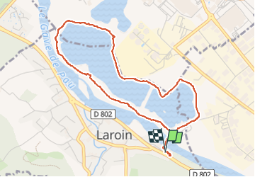

Length
5.1 km

Max alt
167 m

Uphill gradient
50 m
Km-Effort
5.7 km

Min alt
149 m

Downhill gradient
49 m
Boucle
Yes
Creation date :
2022-12-06 12:52:02.0
Updated on :
2022-12-06 15:13:51.713
2h20
Difficulty : Unknown

FREE GPS app for hiking
 SityTrail
IGN / Geographical institutes
SityTrail Plus
The world is yours!
About
Trail Walking of 5.1 km to be discovered at New Aquitaine, Pyrénées-Atlantiques, Laroin. This trail is proposed by mitch1952.
Positioning
Country:
France
Region :
New Aquitaine
Department/Province :
Pyrénées-Atlantiques
Municipality :
Laroin
Location:
Unknown
Start:(Dec)
Start:(UTM)
707920 ; 4797782 (30T) N.
Comments