


st Martin alberes. gr. retour par chalet ouillat

Erius
User
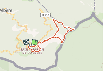

Length
8.7 km

Max alt
1118 m

Uphill gradient
508 m
Km-Effort
15.5 km

Min alt
624 m

Downhill gradient
511 m
Boucle
Yes
Creation date :
2022-11-30 09:09:45.157
Updated on :
2022-12-06 21:33:55.596
3h01
Difficulty : Medium

FREE GPS app for hiking
 SityTrail
IGN / Geographical institutes
SityTrail Plus
The world is yours!
About
Trail Walking of 8.7 km to be discovered at Occitania, Pyrénées-Orientales, L'Albère. This trail is proposed by Erius.
Description
3h 508m 7.8 km
Positioning
Country:
France
Region :
Occitania
Department/Province :
Pyrénées-Orientales
Municipality :
L'Albère
Location:
Unknown
Start:(Dec)
Start:(UTM)
492554 ; 4701550 (31T) N.
Comments