


GR 10 28

chasle
User

Length
22 km

Max alt
2433 m

Uphill gradient
392 m
Km-Effort
29 km

Min alt
1614 m

Downhill gradient
1004 m
Boucle
No
Creation date :
2022-12-07 11:04:42.757
Updated on :
2022-12-07 11:05:13.421
6h36
Difficulty : Difficult

FREE GPS app for hiking
 SityTrail
IGN / Geographical institutes
SityTrail Plus
The world is yours!
About
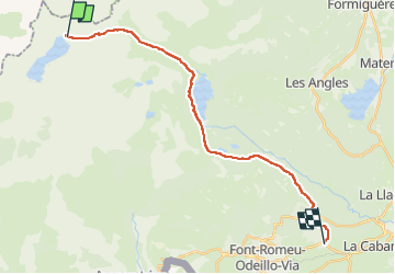
Trail Walking of 22 km to be discovered at Occitania, Pyrénées-Orientales, Angoustrine-Villeneuve-des-Escaldes. This trail is proposed by chasle.
Positioning
Country:
France
Region :
Occitania
Department/Province :
Pyrénées-Orientales
Municipality :
Angoustrine-Villeneuve-des-Escaldes
Location:
Unknown
Start:(Dec)
Start:(UTM)
411079 ; 4716852 (31T) N.
Comments