


GR 10 29

chasle
User
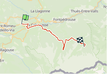

Length
23 km

Max alt
2387 m

Uphill gradient
1351 m
Km-Effort
40 km

Min alt
1477 m

Downhill gradient
1134 m
Boucle
No
Creation date :
2022-12-07 12:57:41.834
Updated on :
2022-12-07 12:58:16.688
9h08
Difficulty : Difficult

FREE GPS app for hiking
 SityTrail
IGN / Geographical institutes
SityTrail Plus
The world is yours!
About
Trail Walking of 23 km to be discovered at Occitania, Pyrénées-Orientales, Bolquère. This trail is proposed by chasle.
Positioning
Country:
France
Region :
Occitania
Department/Province :
Pyrénées-Orientales
Municipality :
Bolquère
Location:
Unknown
Start:(Dec)
Start:(UTM)
424317 ; 4706013 (31T) N.
Comments