


GR 10 31

chasle
User
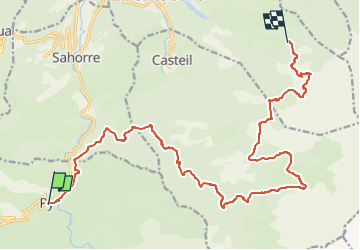

Length
21 km

Max alt
2130 m

Uphill gradient
1396 m
Km-Effort
37 km

Min alt
934 m

Downhill gradient
678 m
Boucle
No
Creation date :
2022-12-07 13:05:41.17
Updated on :
2022-12-07 13:06:22.853
8h27
Difficulty : Difficult

FREE GPS app for hiking
 SityTrail
IGN / Geographical institutes
SityTrail Plus
The world is yours!
About
Trail Walking of 21 km to be discovered at Occitania, Pyrénées-Orientales, Py. This trail is proposed by chasle.
Positioning
Country:
France
Region :
Occitania
Department/Province :
Pyrénées-Orientales
Municipality :
Py
Location:
Unknown
Start:(Dec)
Start:(UTM)
446705 ; 4704999 (31T) N.
Comments