


GR 10 36

chasle
User
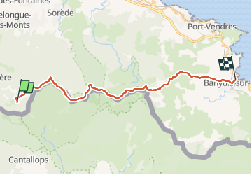

Length
26 km

Max alt
1247 m

Uphill gradient
1057 m
Km-Effort
42 km

Min alt
4 m

Downhill gradient
1705 m
Boucle
No
Creation date :
2022-12-07 13:42:53.763
Updated on :
2022-12-07 13:45:07.783
9h32
Difficulty : Difficult

FREE GPS app for hiking
 SityTrail
IGN / Geographical institutes
SityTrail Plus
The world is yours!
About
Trail Walking of 26 km to be discovered at Occitania, Pyrénées-Orientales, L'Albère. This trail is proposed by chasle.
Positioning
Country:
France
Region :
Occitania
Department/Province :
Pyrénées-Orientales
Municipality :
L'Albère
Location:
Unknown
Start:(Dec)
Start:(UTM)
492963 ; 4701407 (31T) N.
Comments