


Etriac 24-09-2014

jmrobin
User
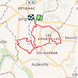

Length
14.7 km

Max alt
145 m

Uphill gradient
264 m
Km-Effort
18.2 km

Min alt
62 m

Downhill gradient
263 m
Boucle
Yes
Creation date :
2019-03-04 10:38:11.897
Updated on :
2019-03-04 10:38:11.91
3h59
Difficulty : Medium

FREE GPS app for hiking
 SityTrail
IGN / Geographical institutes
SityTrail Plus
The world is yours!
About
Trail Walking of 14.7 km to be discovered at New Aquitaine, Charente, Étriac. This trail is proposed by jmrobin.


Positioning
Country:
France
Region :
New Aquitaine
Department/Province :
Charente
Municipality :
Étriac
Location:
Unknown
Start:(Dec)
Start:(UTM)
732280 ; 5045911 (30T) N.
Comments
excellent guide topo