


De saint felious à saint fellious

nicolasdresse
User

Length
7.5 km

Max alt
519 m

Uphill gradient
191 m
Km-Effort
10 km

Min alt
345 m

Downhill gradient
191 m
Boucle
Yes
Creation date :
2022-12-29 14:45:10.0
Updated on :
2022-12-29 16:58:27.6
2h12
Difficulty : Medium

FREE GPS app for hiking
 SityTrail
IGN / Geographical institutes
SityTrail Plus
The world is yours!
About
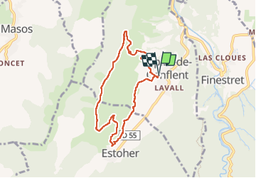
Trail Walking of 7.5 km to be discovered at Occitania, Pyrénées-Orientales, Espira-de-Conflent. This trail is proposed by nicolasdresse.
Photos


Positioning
Country:
France
Region :
Occitania
Department/Province :
Pyrénées-Orientales
Municipality :
Espira-de-Conflent
Location:
Unknown
Start:(Dec)
Start:(UTM)
458673 ; 4718211 (31T) N.
Comments