


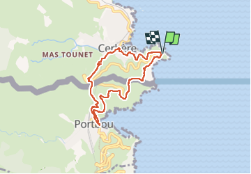
Boucle cap Cerbère Portbou Cerbère retour

jopost
User

Length
7.5 km

Max alt
175 m

Uphill gradient
342 m
Km-Effort
12 km

Min alt
5 m

Downhill gradient
338 m
Boucle
Yes
Creation date :
2022-12-31 08:31:59.608
Updated on :
2023-01-07 08:34:00.742
2h17
Difficulty : Medium

FREE GPS app for hiking
 SityTrail
IGN / Geographical institutes
SityTrail Plus
The world is yours!
About
Trail Walking of 7.5 km to be discovered at Occitania, Pyrénées-Orientales, Cerbère. This trail is proposed by jopost.
Positioning
Country:
France
Region :
Occitania
Department/Province :
Pyrénées-Orientales
Municipality :
Cerbère
Location:
Unknown
Start:(Dec)
Start:(UTM)
514459 ; 4698669 (31T) N.
Comments