


Tanais

Domi33290
User
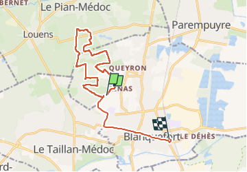

Length
15.5 km

Max alt
46 m

Uphill gradient
107 m
Km-Effort
17 km

Min alt
13 m

Downhill gradient
124 m
Boucle
No
Creation date :
2023-01-15 08:00:07.213
Updated on :
2023-01-15 11:57:55.554
3h57
Difficulty : Easy

FREE GPS app for hiking
 SityTrail
IGN / Geographical institutes
SityTrail Plus
The world is yours!
About
Trail Walking of 15.5 km to be discovered at New Aquitaine, Gironde, Blanquefort. This trail is proposed by Domi33290.
Positioning
Country:
France
Region :
New Aquitaine
Department/Province :
Gironde
Municipality :
Blanquefort
Location:
Unknown
Start:(Dec)
Start:(UTM)
685241 ; 4977142 (30T) N.
Comments