


Blaye Four

taguette
User
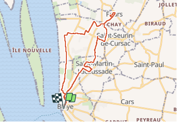

Length
17.5 km

Max alt
30 m

Uphill gradient
130 m
Km-Effort
19.2 km

Min alt
1 m

Downhill gradient
131 m
Boucle
Yes
Creation date :
2023-01-06 08:07:49.229
Updated on :
2023-01-16 08:58:17.572
3h21
Difficulty : Medium

FREE GPS app for hiking
 SityTrail
IGN / Geographical institutes
SityTrail Plus
The world is yours!
About
Trail Walking of 17.5 km to be discovered at New Aquitaine, Gironde, Blaye. This trail is proposed by taguette.
Positioning
Country:
France
Region :
New Aquitaine
Department/Province :
Gironde
Municipality :
Blaye
Location:
Unknown
Start:(Dec)
Start:(UTM)
683692 ; 4999596 (30T) N.
Comments