


23 01 15 retour.Huss Schafert

jmbilger
User

Length
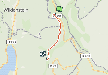
2.4 km

Max alt
1166 m

Uphill gradient
2 m
Km-Effort
3.2 km

Min alt
939 m

Downhill gradient
222 m
Boucle
No
Creation date :
2023-01-15 14:26:49.0
Updated on :
2023-01-17 13:06:32.062
33m
Difficulty : Easy

FREE GPS app for hiking
 SityTrail
IGN / Geographical institutes
SityTrail Plus
The world is yours!
About
Trail Walking of 2.4 km to be discovered at Grand Est, Haut-Rhin, Kruth. This trail is proposed by jmbilger.
Positioning
Country:
France
Region :
Grand Est
Department/Province :
Haut-Rhin
Municipality :
Kruth
Location:
Unknown
Start:(Dec)
Start:(UTM)
349554 ; 5315571 (32T) N.
Comments