


rando copain Willer Sudel 21/01

chantalwaltzer
User
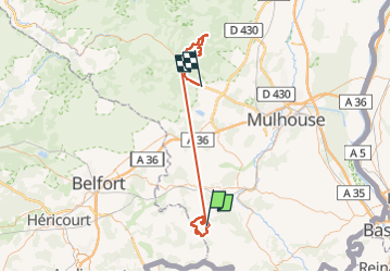

Length
78 km

Max alt
968 m

Uphill gradient
2198 m
Km-Effort
108 km

Min alt
287 m

Downhill gradient
2253 m
Boucle
No
Creation date :
2023-01-19 08:48:59.0
Updated on :
2023-01-24 07:46:28.451
13h41
Difficulty : Medium

FREE GPS app for hiking
 SityTrail
IGN / Geographical institutes
SityTrail Plus
The world is yours!
About
Trail Walking of 78 km to be discovered at Grand Est, Haut-Rhin, Hindlingen. This trail is proposed by chantalwaltzer.
Description
neige
Positioning
Country:
France
Region :
Grand Est
Department/Province :
Haut-Rhin
Municipality :
Hindlingen
Location:
Unknown
Start:(Dec)
Start:(UTM)
359806 ; 5269843 (32T) N.
Comments