Trail Mountain bike Fréjus - 53 km Esterel - Photo
 donda
donda

User

© OpenStreetMap contributors
Length
Length
53 km
Max alt
Max alt
469 m
Uphill gradient
Uphill gradient
1045 m
Km-Effort
Km-Effort  
67 km
Min alt
Min alt
3 m
Downhill gradient
Downhill gradient
1045 m
Boucle
Boucle
Yes
Creation date :
2023-01-29 07:59:57.404
Updated on :
2023-01-30 14:00:16.268

(0 Reviews)

Mountain bike
Mountain bike
3h16
Difficulty : Very difficult

Scan this QR Code to open this trail in the SityTrail application

FREE GPS app for hiking

Logo SityTrail SityTrail

IGN / Geographical institutes

Download SityTrail from the App Store Download SityTrail from Google Play

Logo SityTrail SityTrail World

The world is yours!

Download SityTrail from the App Store Download SityTrail from Google Play Download SityTrail on Huawei AppGallery

About

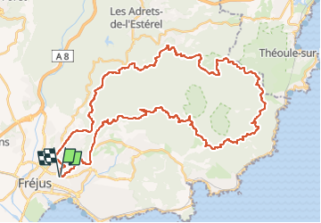
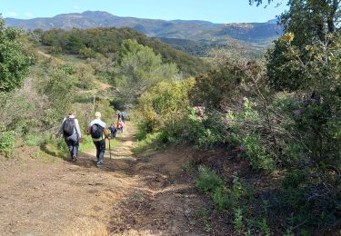
Trail Mountain bike of 53 km to be discovered at Provence-Alpes-Côte d'Azur, Var, Fréjus. This trail is proposed by donda.

Description

Parking Léotard - Tour de Mare - MF de la Louve - Route d'Italie  MF des Cantonniers - MF du Malpey - Route des Cols - MF de la Duchesse - Baisse violette - Col des Suvières - MF des 3 Termes - Col de la Cadière - Col N.Dame - Col des Lentisques - Col de l'Evêque - Col deBelle Barbe - Col du Mistral - Pont du Perthus - MF du Roussivau - Piste Castelli - Carrefour de la Colle Douce - Oratoire Guérin - Retour parking.

Elevation profile

Photos

Positioning

Country:
France
Region :
Provence-Alpes-Côte d'Azur
Department/Province :
Var
Municipality :
Fréjus
Location:
Unknown
Start:(UTM)
318411 ; 4811751 (32T) N.

Trails nearby

Trail Walking Fréjus - Etang de Villepey - Photo
Walking
marmotte83

Walking

Very easy
(2)
Fréjus, Provence-Alpes-Côte d'Azur, Var, France
6.5 km | 7 km-effort
3h 4min
Yes
Trail Mountain bike Fréjus - grand tour esterel par belles pistes larges - Photo
Mountain bike
Margaide

Mountain bike

Easy
(2)
Fréjus, Provence-Alpes-Côte d'Azur, Var, France
31 km | 40 km-effort
3h 17min
Yes
Trail Walking Fréjus - Mont Vinaigre par Colle Douce - Photo
Walking

Walking

Very difficult
(1)
Fréjus, Provence-Alpes-Côte d'Azur, Var, France
22 km | 33 km-effort
6h 1min
Yes
Trail Walking Fréjus - Sortie du lundi 8 janvier aprés-midi - Photo
Walking
OB83700

Walking

Medium
(1)
Fréjus, Provence-Alpes-Côte d'Azur, Var, France
7.4 km | 10.7 km-effort
2h 50min
Yes
Trail Walking Saint-Raphaël - Peïre Sarade à Ancienne Carrière de Dramont - Photo
Walking
LtZIP

Walking

Very easy
(1)
Saint-Raphaël, Provence-Alpes-Côte d'Azur, Var, France
13.6 km | 19.5 km-effort
4h 4min
Yes
Trail Mountain bike Fréjus - Roc Odyssée 2015 - Photo
Mountain bike
Dominick

Mountain bike

Medium
(1)
Fréjus, Provence-Alpes-Côte d'Azur, Var, France
37 km | 47 km-effort
3h 55min
No
Trail Walking Fréjus - VVA 2109 Etangs de Villepey - Photo
Walking
jmheydorff

Walking

Easy
(1)
Fréjus, Provence-Alpes-Côte d'Azur, Var, France
17 km | 19.6 km-effort
4h 13min
Yes
Trail Mountain bike Fréjus - Tour des Petites Maures - Photo
Mountain bike
barberou

Mountain bike

Very easy
(2)
Fréjus, Provence-Alpes-Côte d'Azur, Var, France
40 km | 52 km-effort
Unknown
Yes
Trail Walking Saint-Raphaël - Estérel / Le Crapas, Les Ferrières, Caous  - Photo
Walking
Pascal-83

Walking

Difficult
Saint-Raphaël, Provence-Alpes-Côte d'Azur, Var, France
11.1 km | 15.5 km-effort
3h 31min
Yes


Close
My subscriptions