


45e parallèle Corrençon

dan69390
User
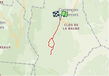

Length
8 km

Max alt
1280 m

Uphill gradient
174 m
Km-Effort
10.3 km

Min alt
1142 m

Downhill gradient
175 m
Boucle
Yes
Creation date :
2023-01-31 09:23:04.0
Updated on :
2023-01-31 12:30:34.608
3h07
Difficulty : Medium

FREE GPS app for hiking
 SityTrail
IGN / Geographical institutes
SityTrail Plus
The world is yours!
About
Trail Walking of 8 km to be discovered at Auvergne-Rhône-Alpes, Isère, Corrençon-en-Vercors. This trail is proposed by dan69390.
Positioning
Country:
France
Region :
Auvergne-Rhône-Alpes
Department/Province :
Isère
Municipality :
Corrençon-en-Vercors
Location:
Unknown
Start:(Dec)
Start:(UTM)
698364 ; 4988803 (31T) N.
Comments