


2022 02 02

E.BURCK
User
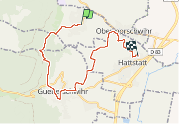

Length
7.5 km

Max alt
444 m

Uphill gradient
166 m
Km-Effort
10.1 km

Min alt
207 m

Downhill gradient
291 m
Boucle
No
Creation date :
2023-02-02 09:08:22.803
Updated on :
2023-02-02 14:07:38.927
2h28
Difficulty : Medium

FREE GPS app for hiking
 SityTrail
IGN / Geographical institutes
SityTrail Plus
The world is yours!
About
Trail Walking of 7.5 km to be discovered at Grand Est, Haut-Rhin, Vœgtlinshoffen. This trail is proposed by E.BURCK.
Positioning
Country:
France
Region :
Grand Est
Department/Province :
Haut-Rhin
Municipality :
Vœgtlinshoffen
Location:
Unknown
Start:(Dec)
Start:(UTM)
371922 ; 5319902 (32U) N.
Comments