


La Rhune

taguette
User
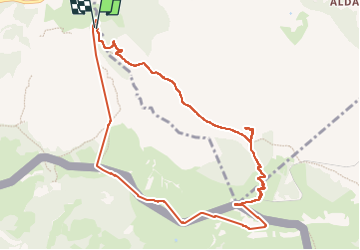

Length
11.3 km

Max alt
897 m

Uphill gradient
832 m
Km-Effort
22 km

Min alt
96 m

Downhill gradient
835 m
Boucle
Yes
Creation date :
2023-02-03 09:46:42.414
Updated on :
2023-02-03 14:25:27.803
4h36
Difficulty : Difficult

FREE GPS app for hiking
 SityTrail
IGN / Geographical institutes
SityTrail Plus
The world is yours!
About
Trail Walking of 11.3 km to be discovered at New Aquitaine, Pyrénées-Atlantiques, Ascain. This trail is proposed by taguette.
Positioning
Country:
France
Region :
New Aquitaine
Department/Province :
Pyrénées-Atlantiques
Municipality :
Ascain
Location:
Unknown
Start:(Dec)
Start:(UTM)
608664 ; 4798464 (30T) N.
Comments