


Valmeinier / le gros Cret

laurentnecca
User
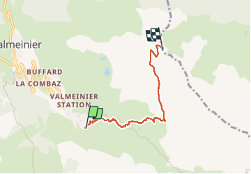

Length
4.6 km

Max alt
2574 m

Uphill gradient
725 m
Km-Effort
11.9 km

Min alt
1844 m

Downhill gradient
2 m
Boucle
No
Creation date :
2023-02-04 09:32:34.708
Updated on :
2023-02-04 12:23:52.584
2h50
Difficulty : Medium

FREE GPS app for hiking
 SityTrail
IGN / Geographical institutes
SityTrail Plus
The world is yours!
About
Trail Touring skiing of 4.6 km to be discovered at Auvergne-Rhône-Alpes, Savoy, Valmeinier. This trail is proposed by laurentnecca.
Positioning
Country:
France
Region :
Auvergne-Rhône-Alpes
Department/Province :
Savoy
Municipality :
Valmeinier
Location:
Unknown
Start:(Dec)
Start:(UTM)
303396 ; 5004957 (32T) N.
Comments