


JD 16/20 Mulhouse : canal, Fonderie, Illberg, bords de l'Ill 6km 40m

argonneuweg
User
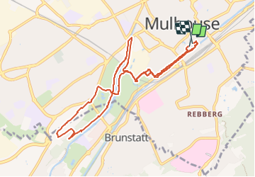

Length
9.8 km

Max alt
291 m

Uphill gradient
116 m
Km-Effort
11.3 km

Min alt
231 m

Downhill gradient
109 m
Boucle
Yes
Creation date :
2023-02-04 13:12:49.0
Updated on :
2023-03-04 19:06:04.16
1h39
Difficulty : Medium

FREE GPS app for hiking
 SityTrail
IGN / Geographical institutes
SityTrail Plus
The world is yours!
About
Trail Walking of 9.8 km to be discovered at Grand Est, Haut-Rhin, Mulhouse. This trail is proposed by argonneuweg.
Description
Départ du parking de la CCI
Positioning
Country:
France
Region :
Grand Est
Department/Province :
Haut-Rhin
Municipality :
Mulhouse
Location:
Unknown
Start:(Dec)
Start:(UTM)
375613 ; 5289058 (32T) N.
Comments