10.7 km | 17.9 km-effort
Venanson
© OpenStreetMap contributors
Walking
2h48
Difficulty : Easy
Length
5.3 km
Max alt
1171 m
Uphill gradient
290 m
Km-Effort
9.1 km
Min alt
907 m
Downhill gradient
290 m
Boucle
Yes
Creation date :
2023-02-05 10:41:15.538
Updated on :
2023-02-05 18:30:29.371
2h48
Difficulty : Easy
FREE GPS app for hiking
About
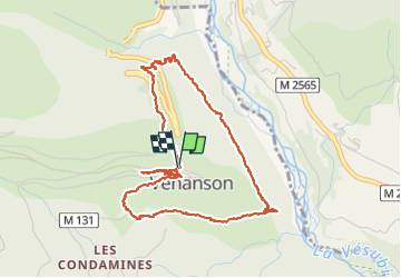
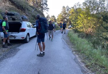
Trail Walking of 5.3 km to be discovered at Provence-Alpes-Côte d'Azur, Maritime Alps, Venanson. This trail is proposed by Jean-François Thibaud.
Description
Boucle autour de Venanson. Rien d'extraordinaire. Rando courte pour se dégourdir les jambes.
Positioning
Country:
France
Region :
Provence-Alpes-Côte d'Azur
Department/Province :
Maritime Alps
Municipality :
Venanson
Location:
Unknown
Start:(Dec)
Start:(UTM)
360059 ; 4879319 (32T) N.
Comments
Trails nearby
La Malouna
Walking
Medium
(1)
Venanson,
Provence-Alpes-Côte d'Azur,
Maritime Alps,
France
5h 20min
Yes
Le Caïre Gros
On foot
Medium
Valdeblore,
Provence-Alpes-Côte d'Azur,
Maritime Alps,
France
9.8 km | 20 km-effort
4h 38min
Yes
Circuit du Conquet
On foot
Medium
Venanson,
Provence-Alpes-Côte d'Azur,
Maritime Alps,
France
10.2 km | 21 km-effort
4h 45min
Yes
Circuit du Tournairet
On foot
Easy
Lantosque,
Provence-Alpes-Côte d'Azur,
Maritime Alps,
France
9.6 km | 16.2 km-effort
3h 41min
Yes
St Dalmas Valdeblore
Walking
Easy
Valdeblore,
Provence-Alpes-Côte d'Azur,
Maritime Alps,
France
8.7 km | 12.3 km-effort
2h 26min
Yes
La Colmiane : Mont Peipori
Walking
Difficult
Valdeblore,
Provence-Alpes-Côte d'Azur,
Maritime Alps,
France
16 km | 32 km-effort
5h 0min
Yes
tour du pic de colmiane
Walking
Medium
Valdeblore,
Provence-Alpes-Côte d'Azur,
Maritime Alps,
France
8 km | 14.7 km-effort
2h 24min
Yes
Le Caire gros
Walking
Medium
Valdeblore,
Provence-Alpes-Côte d'Azur,
Maritime Alps,
France
10.4 km | 21 km-effort
3h 24min
Yes
st dalmas par les vacheries millefond et rimplas
Walking
Difficult
Valdeblore,
Provence-Alpes-Côte d'Azur,
Maritime Alps,
France
25 km | 44 km-effort
6h 11min
Yes