


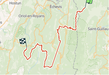
Trav. du Vercors en MN. Trace complète des 4 jours.

patjobou
User

Length
75 km

Max alt
1667 m

Uphill gradient
2667 m
Km-Effort
111 km

Min alt
750 m

Downhill gradient
2687 m
Boucle
No
Creation date :
2023-02-06 20:21:15.442
Updated on :
2023-02-12 19:01:20.661
0m
Difficulty : Medium

FREE GPS app for hiking
 SityTrail
IGN / Geographical institutes
SityTrail Plus
The world is yours!
About
Trail Nordic walking of 75 km to be discovered at Auvergne-Rhône-Alpes, Isère, Corrençon-en-Vercors. This trail is proposed by patjobou.

Positioning
Country:
France
Region :
Auvergne-Rhône-Alpes
Department/Province :
Isère
Municipality :
Corrençon-en-Vercors
Location:
Unknown
Start:(Dec)
Start:(UTM)
698328 ; 4988676 (31T) N.
Comments