


TRK000

JCLUTT
User
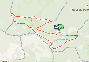

Length
10.5 km

Max alt
1037 m

Uphill gradient
447 m
Km-Effort
16.5 km

Min alt
734 m

Downhill gradient
451 m
Boucle
Yes
Creation date :
2023-02-08 08:27:34.921
Updated on :
2023-02-08 08:36:34.423
3h44
Difficulty : Difficult

FREE GPS app for hiking
 SityTrail
IGN / Geographical institutes
SityTrail Plus
The world is yours!
About
Trail Walking of 10.5 km to be discovered at Grand Est, Haut-Rhin, Kirchberg. This trail is proposed by JCLUTT.
Description
Randonnée de difficulté moyenne de reprise !
Positioning
Country:
France
Region :
Grand Est
Department/Province :
Haut-Rhin
Municipality :
Kirchberg
Location:
Unknown
Start:(Dec)
Start:(UTM)
344831 ; 5293776 (32T) N.
Comments