


9558138

frizou83
User
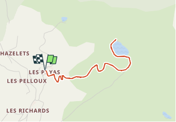

Length
4.6 km

Max alt
1506 m

Uphill gradient
201 m
Km-Effort
7.3 km

Min alt
1307 m

Downhill gradient
202 m
Boucle
Yes
Creation date :
2023-02-08 09:04:23.687
Updated on :
2023-02-08 09:05:58.122
1h39
Difficulty : Medium

FREE GPS app for hiking
 SityTrail
IGN / Geographical institutes
SityTrail Plus
The world is yours!
About
Trail Walking of 4.6 km to be discovered at Provence-Alpes-Côte d'Azur, Hautes-Alpes, Saint-Bonnet-en-Champsaur. This trail is proposed by frizou83.
Positioning
Country:
France
Region :
Provence-Alpes-Côte d'Azur
Department/Province :
Hautes-Alpes
Municipality :
Saint-Bonnet-en-Champsaur
Location:
Bénévent-et-Charbillac
Start:(Dec)
Start:(UTM)
270725 ; 4953169 (32T) N.
Comments