


Rando pour Christophe

patrickbeyrath
User
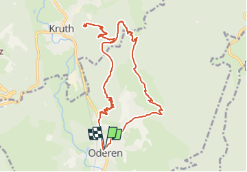

Length
10.9 km

Max alt
832 m

Uphill gradient
569 m
Km-Effort
18.5 km

Min alt
463 m

Downhill gradient
570 m
Boucle
Yes
Creation date :
2023-02-09 16:44:29.073
Updated on :
2023-02-09 16:45:47.208
4h11
Difficulty : Medium

FREE GPS app for hiking
 SityTrail
IGN / Geographical institutes
SityTrail Plus
The world is yours!
About
Trail Walking of 10.9 km to be discovered at Grand Est, Haut-Rhin, Oderen. This trail is proposed by patrickbeyrath.
Positioning
Country:
France
Region :
Grand Est
Department/Province :
Haut-Rhin
Municipality :
Oderen
Location:
Unknown
Start:(Dec)
Start:(UTM)
348728 ; 5308325 (32T) N.
Comments