


Mâa, Brouchon, Lessègues, Timbou, Miconine, Carreyre, Manchou - 9.4

hartmannpat
User
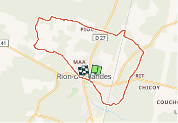

Length
9.4 km

Max alt
88 m

Uphill gradient
95 m
Km-Effort
10.7 km

Min alt
62 m

Downhill gradient
93 m
Boucle
Yes
Creation date :
2023-02-16 13:01:35.688
Updated on :
2023-03-27 07:33:50.594
2h00
Difficulty : Medium

FREE GPS app for hiking
 SityTrail
IGN / Geographical institutes
SityTrail Plus
The world is yours!
About
Trail Walking of 9.4 km to be discovered at New Aquitaine, Landes, Rion-des-Landes. This trail is proposed by hartmannpat.
Positioning
Country:
France
Region :
New Aquitaine
Department/Province :
Landes
Municipality :
Rion-des-Landes
Location:
Rion-des-Landes
Start:(Dec)
Start:(UTM)
666903 ; 4866644 (30T) N.
Comments