


vions

Henri.Vekemans
User

Length
3.6 km

Max alt
238 m

Uphill gradient
10 m
Km-Effort
3.7 km

Min alt
232 m

Downhill gradient
10 m
Boucle
Yes
Creation date :
2023-02-18 14:15:36.283
Updated on :
2023-02-18 15:06:06.786
50m
Difficulty : Easy

FREE GPS app for hiking
 SityTrail
IGN / Geographical institutes
SityTrail Plus
The world is yours!
About
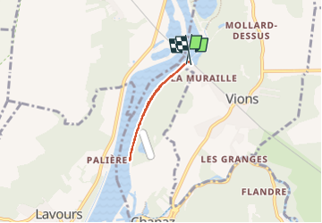
Trail Walking of 3.6 km to be discovered at Auvergne-Rhône-Alpes, Savoy, Vions. This trail is proposed by Henri.Vekemans.
Positioning
Country:
France
Region :
Auvergne-Rhône-Alpes
Department/Province :
Savoy
Municipality :
Vions
Location:
Unknown
Start:(Dec)
Start:(UTM)
717280 ; 5078951 (31T) N.
Comments