


23 02 20 autour de Rantzwiller

jmbilger
User
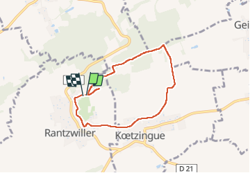

Length
6.3 km

Max alt
359 m

Uphill gradient
117 m
Km-Effort
7.8 km

Min alt
293 m

Downhill gradient
114 m
Boucle
Yes
Creation date :
2023-02-19 13:40:25.0
Updated on :
2023-02-19 15:28:55.431
1h37
Difficulty : Medium

FREE GPS app for hiking
 SityTrail
IGN / Geographical institutes
SityTrail Plus
The world is yours!
About
Trail Walking of 6.3 km to be discovered at Grand Est, Haut-Rhin, Rantzwiller. This trail is proposed by jmbilger.
Positioning
Country:
France
Region :
Grand Est
Department/Province :
Haut-Rhin
Municipality :
Rantzwiller
Location:
Unknown
Start:(Dec)
Start:(UTM)
378277 ; 5279396 (32T) N.
Comments