Trail Walking Brié-et-Angonnes - Brié - Montchabout - Sommet de Pravena - Photo

Brié - Montchabout - Sommet de Pravena

 flip38
flip38

User

© OpenStreetMap contributors
Length
Length
14.5 km
Max alt
Max alt
737 m
Uphill gradient
Uphill gradient
623 m
Km-Effort
Km-Effort  
23 km
Min alt
Min alt
309 m
Downhill gradient
Downhill gradient
622 m
Boucle
Boucle
Yes
Creation date :
2023-02-21 12:18:13.311
Updated on :
2023-02-27 11:21:13.038

(0 Reviews)

Walking
Walking
4h19
Difficulty : Medium

Scan this QR Code to open this trail in the SityTrail application

FREE GPS app for hiking

Logo SityTrail SityTrail

IGN / Geographical institutes

Download SityTrail from the App Store Download SityTrail from Google Play

Logo SityTrail SityTrail World

The world is yours!

Download SityTrail from the App Store Download SityTrail from Google Play Download SityTrail on Huawei AppGallery

About

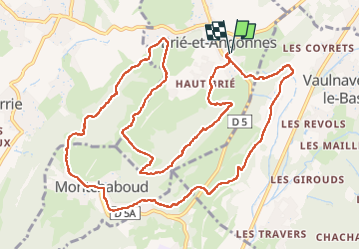
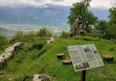
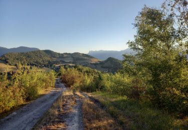
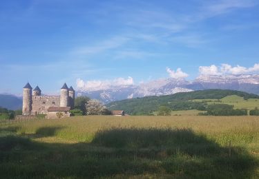
Trail Walking of 14.5 km to be discovered at Auvergne-Rhône-Alpes, Isère, Brié-et-Angonnes. This trail is proposed by flip38.

Description

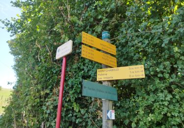
Belle petite boucle printanière sur les hauteurs de Montchabout et de Brié.
Parcours agréable, bons sentiers ou chemins.

Elevation profile

Photos

Positioning

Country:
France
Region :
Auvergne-Rhône-Alpes
Department/Province :
Isère
Municipality :
Brié-et-Angonnes
Location:
Unknown
Start:(UTM)
719266 ; 4999132 (31T) N.

Trails nearby

Trail On foot Saint-Martin-d'Uriage - Circuit des Curistes - Photo
On foot
PRO

On foot

Easy
Saint-Martin-d'Uriage, Auvergne-Rhône-Alpes, Isère, France
5.9 km | 7.8 km-effort
1h 46min
Yes
Trail On foot Saint-Martin-d'Uriage - Circuit des Crêtes - Photo
On foot
PRO

On foot

Easy
Saint-Martin-d'Uriage, Auvergne-Rhône-Alpes, Isère, France
9.5 km | 13.6 km-effort
3h 5min
Yes
Trail On foot Saint-Martin-d'Uriage - Circuit du Bit - Photo
On foot
PRO

On foot

Easy
Saint-Martin-d'Uriage, Auvergne-Rhône-Alpes, Isère, France
9.1 km | 16.3 km-effort
3h 41min
Yes
Trail Running Vizille - Echappée Belle 2013 - Photo
Running
micleo66

Running

Very difficult
(1)
Vizille, Auvergne-Rhône-Alpes, Isère, France
136 km | 279 km-effort
60h 0min
No
Trail Walking Champ-sur-Drac - 38 Couvent St Michel Champ / drac - Photo
Walking
ericf64

Walking

Medium
Champ-sur-Drac, Auvergne-Rhône-Alpes, Isère, France
9.4 km | 19.7 km-effort
3h 0min
Yes
Trail Nordic walking Jarrie - Mon chabou -haut jarret  - Photo
Nordic walking
Youcef Atallah

Nordic walking

Very easy
Jarrie, Auvergne-Rhône-Alpes, Isère, France
10.2 km | 14.6 km-effort
2h 21min
Yes
Trail Walking Vaulnaveys-le-Bas - Montchaffrey/chartreuse de premol - Photo
Walking
Youcef Atallah

Walking

Very difficult
Vaulnaveys-le-Bas, Auvergne-Rhône-Alpes, Isère, France
15 km | 23 km-effort
3h 54min
Yes
Trail Walking Brié-et-Angonnes - Brié- Table d'orientation  - Photo
Walking
crocau

Walking

Very easy
Brié-et-Angonnes, Auvergne-Rhône-Alpes, Isère, France
3.1 km | 4.3 km-effort
59min
Yes
Trail Nordic walking Jarrie - Château de Bon Repos, Bois de Bouchassey, Saut du Moine - Photo
Nordic walking
patjobou

Nordic walking

Easy
Jarrie, Auvergne-Rhône-Alpes, Isère, France
9.6 km | 13.7 km-effort
2h 18min
Yes


Close
My subscriptions