


entre ponts et passerelles

Lucquiaud
User

Length
7.9 km

Max alt
126 m

Uphill gradient
163 m
Km-Effort
10.1 km

Min alt
74 m

Downhill gradient
164 m
Boucle
Yes
Creation date :
2023-02-22 12:36:59.509
Updated on :
2023-02-22 14:48:35.755
13m
Difficulty : Easy

FREE GPS app for hiking
 SityTrail
IGN / Geographical institutes
SityTrail Plus
The world is yours!
About
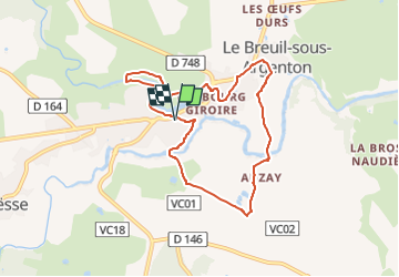
Trail Walking of 7.9 km to be discovered at New Aquitaine, Deux-Sèvres, Argentonnay. This trail is proposed by Lucquiaud.
Description
randonnée pédestre documentée sur Sentiers de France au départ de Argenton les Vallées
Positioning
Country:
France
Region :
New Aquitaine
Department/Province :
Deux-Sèvres
Municipality :
Argentonnay
Location:
Unknown
Start:(Dec)
Start:(UTM)
694205 ; 5206693 (30T) N.
Comments
Très belle ballade que j'ai fait en sens inverse. Mais de grosses montées . A noter, le chemin avant Le Breuil a été effacé par un agriculteur. Il faudra traversé ce petit et charmant petit village.