


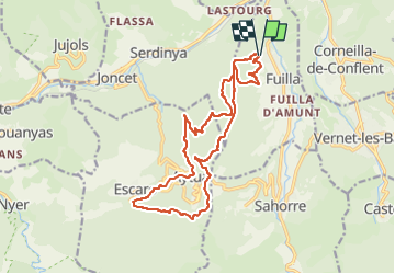
chemin des baillouberes , FUILLA

FAUCET
User

Length
18.1 km

Max alt
1045 m

Uphill gradient
741 m
Km-Effort
28 km

Min alt
548 m

Downhill gradient
741 m
Boucle
Yes
Creation date :
2023-02-25 08:01:05.246
Updated on :
2023-02-25 08:01:07.296
6h21
Difficulty : Very difficult

FREE GPS app for hiking
 SityTrail
IGN / Geographical institutes
SityTrail Plus
The world is yours!
About
Trail Walking of 18.1 km to be discovered at Occitania, Pyrénées-Orientales, Fuilla. This trail is proposed by FAUCET.
Positioning
Country:
France
Region :
Occitania
Department/Province :
Pyrénées-Orientales
Municipality :
Fuilla
Location:
Unknown
Start:(Dec)
Start:(UTM)
447016 ; 4712988 (31T) N.
Comments