


entre-vedrenne-et-la-brette

viam19
User
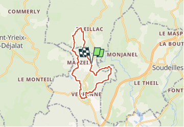

Length
11.7 km

Max alt
708 m

Uphill gradient
295 m
Km-Effort
15.7 km

Min alt
615 m

Downhill gradient
299 m
Boucle
Yes
Creation date :
2023-02-25 15:28:04.864
Updated on :
2023-02-25 15:28:04.864
3h33
Difficulty : Difficult

FREE GPS app for hiking
 SityTrail
IGN / Geographical institutes
SityTrail Plus
The world is yours!
About
Trail Walking of 11.7 km to be discovered at New Aquitaine, Corrèze, Égletons. This trail is proposed by viam19.
Positioning
Country:
France
Region :
New Aquitaine
Department/Province :
Corrèze
Municipality :
Égletons
Location:
Unknown
Start:(Dec)
Start:(UTM)
423970 ; 5033003 (31T) N.
Comments
jolie randonnée, manque de petits chemins .