


23 03 05 autour de Bellemagny

jmbilger
User
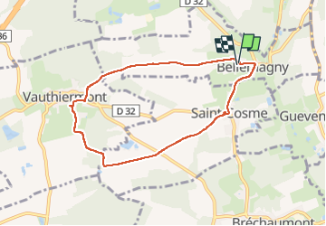

Length
7.4 km

Max alt
411 m

Uphill gradient
101 m
Km-Effort
8.7 km

Min alt
328 m

Downhill gradient
101 m
Boucle
Yes
Creation date :
2023-03-05 09:33:43.0
Updated on :
2023-03-05 11:58:12.104
1h57
Difficulty : Unknown

FREE GPS app for hiking
 SityTrail
IGN / Geographical institutes
SityTrail Plus
The world is yours!
About
Trail Walking of 7.4 km to be discovered at Grand Est, Haut-Rhin, Bellemagny. This trail is proposed by jmbilger.
Positioning
Country:
France
Region :
Grand Est
Department/Province :
Haut-Rhin
Municipality :
Bellemagny
Location:
Unknown
Start:(Dec)
Start:(UTM)
354748 ; 5283613 (32T) N.
Comments