


rando du 04-01-2023

dudu79
User
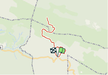

Length
7.5 km

Max alt
1423 m

Uphill gradient
452 m
Km-Effort
13.6 km

Min alt
978 m

Downhill gradient
458 m
Boucle
Yes
Creation date :
2023-01-03 19:17:31.3
Updated on :
2023-03-05 12:18:56.719
3h04
Difficulty : Difficult

FREE GPS app for hiking
 SityTrail
IGN / Geographical institutes
SityTrail Plus
The world is yours!
About
Trail Walking of 7.5 km to be discovered at New Aquitaine, Pyrénées-Atlantiques, Bilhères. This trail is proposed by dudu79.
Positioning
Country:
France
Region :
New Aquitaine
Department/Province :
Pyrénées-Atlantiques
Municipality :
Bilhères
Location:
Unknown
Start:(Dec)
Start:(UTM)
702926 ; 4771676 (30T) N.
Comments