Trail Walking Montclus - Montclus - Photo
 Marco05
Marco05

User

© OpenStreetMap contributors
Length
Length
13 km
Max alt
Max alt
1487 m
Uphill gradient
Uphill gradient
812 m
Km-Effort
Km-Effort  
24 km
Min alt
Min alt
706 m
Downhill gradient
Downhill gradient
805 m
Boucle
Boucle
Yes
Creation date :
2023-03-06 15:49:37.333
Updated on :
2023-03-06 15:59:11.248

(0 Reviews)

Walking
Walking
5h24
Difficulty : Difficult

Scan this QR Code to open this trail in the SityTrail application

FREE GPS app for hiking

Logo SityTrail SityTrail

IGN / Geographical institutes

Download SityTrail from the App Store Download SityTrail from Google Play

Logo SityTrail SityTrail World

The world is yours!

Download SityTrail from the App Store Download SityTrail from Google Play Download SityTrail on Huawei AppGallery

About

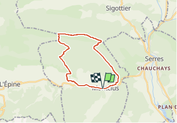
Trail Walking of 13 km to be discovered at Provence-Alpes-Côte d'Azur, Hautes-Alpes, Montclus. This trail is proposed by Marco05.

Description

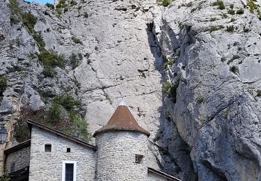
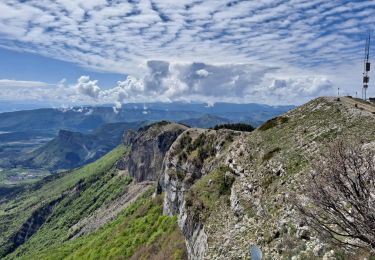
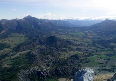
Joli boucle passant à côté du rocher de Jardanne au dessus de Serres.
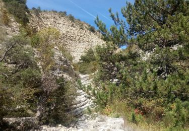
Il faut rester prudent dans certains passages de la crête.
Attention descente un peu raide en partant de l'arête.
Cette sortie est assez physique.
Réservée aux personnes en forme.

Elevation profile

Photos

Positioning

Country:
France
Region :
Provence-Alpes-Côte d'Azur
Department/Province :
Hautes-Alpes
Municipality :
Montclus
Location:
Unknown
Start:(UTM)
713455 ; 4921422 (31T) N.

Trails nearby

Trail Walking Serres - Tour des Baronnies du Buëch - Serres - Montmorin - Photo
Walking
tracegps

Walking

Difficult
(1)
Serres, Provence-Alpes-Côte d'Azur, Hautes-Alpes, France
20 km | 33 km-effort
4h 0min
No
Trail Walking Serres - R32   Au dessus de Serres - Photo
Walking
GUIDE+

Walking

Medium
Serres, Provence-Alpes-Côte d'Azur, Hautes-Alpes, France
5.4 km | 10.5 km-effort
2h 8min
Yes
Trail Walking Sigottier - Boucle des Michons Départ Sigottier 322+ - Photo
Walking
claude nier

Walking

Easy
Sigottier, Provence-Alpes-Côte d'Azur, Hautes-Alpes, France
8.8 km | 13.1 km-effort
3h 20min
Yes
Trail Walking Sigottier - Le Duffre - Photo
Walking
Marco05

Walking

Medium
Sigottier, Provence-Alpes-Côte d'Azur, Hautes-Alpes, France
10.3 km | 19.1 km-effort
4h 19min
Yes
Trail Walking Serres - Rocher de Jardanne - Photo
Walking
Marco05

Walking

Medium
Serres, Provence-Alpes-Côte d'Azur, Hautes-Alpes, France
10.4 km | 19.8 km-effort
4h 30min
Yes
Trail Walking Serres - Rocher de Beaumont - Photo
Walking
Marco05

Walking

Difficult
Serres, Provence-Alpes-Côte d'Azur, Hautes-Alpes, France
11.3 km | 23 km-effort
5h 19min
No
Trail Walking Serres - Arambre - Photo
Walking
Marco05

Walking

Difficult
Serres, Provence-Alpes-Côte d'Azur, Hautes-Alpes, France
6.8 km | 16.9 km-effort
3h 50min
Yes
Trail Walking Serres - 20191212_Serres - Les Trois Boucles - Photo
Walking
PapouBertrand

Walking

Medium
Serres, Provence-Alpes-Côte d'Azur, Hautes-Alpes, France
20 km | 34 km-effort
7h 51min
Yes
Trail Walking Sigottier - R35   La Montagne - Photo
Walking
GUIDE+

Walking

Medium
Sigottier, Provence-Alpes-Côte d'Azur, Hautes-Alpes, France
10.5 km | 18 km-effort
3h 40min
Yes


Close
My subscriptions